Levasseur Map – Burgundy Saône et Loire, France
Département de Saône et Loire, France.
This richly illustrated 19th-century map depicts the Département de Saône-et-Loire in Burgundy in eastern France, showing its towns, rivers, road networks, railways, canals, and administrative boundaries in fine engraved detail. Produced for a French illustrated national atlas, the map reflects the region’s importance as a center of agriculture, viticulture, industry, and trade during the early modern period. Extensive decorative vignettes surround the map, presenting scenes of rural life, farming, forestry, animal husbandry, fishing, and local manufacturing, alongside tools, timber, textiles, barrels, and industrial materials that symbolize the department’s economic activity. Portraits of notable historical figures associated with the region appear within the border, reinforcing the cultural and intellectual identity of Saône-et-Loire. Both informative and visually striking, the map offers a vivid snapshot of regional geography and everyday life in 19th-century France.

Key towns shown include:
Autun, Chalon-sur-Saône, Mâcon, Le Creusot, Montceau-les-Mines, Paray-le-Monial, Charolles, Louhans, Tournus, Cluny, Digoin.
Credits (as printed on the map):
Atlas National Illustré.
Région de l’Est, N° 70.
Dépt. de Saône et Loire.
Paris, Combette, Éditeur, Rue de la Parcheminerie, 15.
Lithographie et gravure par Lallemand.
Condition: Rough edges, some age toning.
Dimensions: Sheet measures 52 x 36 cm

Date of Publication: 1847
Victor Jules Levasseur was a leading French cartographer of the mid-19th century, celebrated for maps that combine precise geographic information with rich allegorical and regional imagery. His work belongs to a period when cartography was closely linked to education, national identity, and visual storytelling.
Levasseur is best known for the Atlas National Illustré des 86 Départements et des Possessions de la France, first published in 1847. This ambitious atlas presented each département with detailed mapping surrounded by decorative vignettes illustrating local agriculture, industries, landscapes, and customs. These elements were designed to make geography both informative and visually engaging, reflecting contemporary interest in regional character and economic life.
The ornamental scenes surrounding many of the maps were drawn by Raymond Bonheur, a respected painter and the father of the celebrated artist Rosa Bonheur. Bonheur’s illustrations contribute significantly to the atlas’s distinctive appearance, grounding the maps in vivid representations of rural labor and everyday life. Individual plate credits are noted where visible.
Highly sought after by collectors, Levasseur’s departmental maps are admired for their exceptional decorative borders, detailed regional content, and their ability to combine cartography with scenes of everyday life and production in 19th-century France.
Most maps from this series measure approximately 33 × 49.5 cm. Please see individual listings for specific dimensions, condition details, and information on margins or trimming.

A cartouche on the right (detail above) describes the region and its celebrities:
CÉLÉBRITÉS.
Transcription (French):
Cipierre brave guerrier gouverneur de Charles IX. Le bénédictin Clément auteur de l’art de vérifier les dates. Jean Cousin peintre et sculpteur. Denon ancien directeur du Musée national. Le général Pressinet. Mᵐᵉ de Genlis. Le général Girault. Le célèbre Greuze peintre de mœurs. Le poëte député Lamartine. Le général H. Lhuillier qui se distingua à Austerlitz. Le profond mathématicien Mathieu aujourd’hui membre du bureau des longitudes. Le grand peintre Prud’hon. Le savant géographe Robert. L’orientaliste Du Ryer. Le médecin Moreau. Le littérateur Sénécé. Enfin le brave général Changarnier qui est né à Autun.
Translation (English):
Cipierre, a brave warrior, governor under Charles IX. The Benedictine Clément, author of The Art of Verifying Dates. Jean Cousin, painter and sculptor. Denon, former director of the National Museum. General Pressinet. Madame de Genlis. General Girault. The celebrated Greuze, painter of moral life scenes. The poet and deputy Lamartine. General H. Lhuillier, who distinguished himself at Austerlitz. The profound mathematician Mathieu, today a member of the Bureau of Longitudes. The great painter Prud’hon. The learned geographer Robert. The orientalist Du Ryer. The physician Moreau. The man of letters Sénécé. Finally, the brave General Changarnier, who was born in Autun.
PRODUCTION, COMMERCE.
Transcription (French):
Le Département contient 812,591 hectares de superficie imposable et 43,882 de non imposable. Les imposables sont 456,333 hectares de terres labourables, 126,655 hectares de prés, 37,936 hectares de vignes, 150,694 hectares de bois, 26,269 hectares de landes, pâtis et bruyères, 14,714 hect. de vergers, jardins, étangs, propriétés bâties &c.
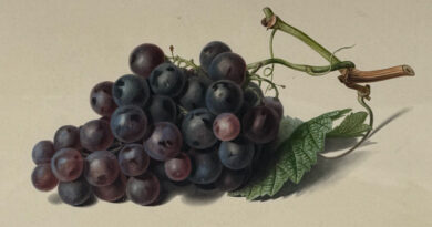
Productions. Grains, chanvre, fruits et légumes en abondance, fourrages, bois, vins excellents parmi lesquels on distingue ceux de la côte Chalonnaise, de Mâcon, de Thoissey et de Moulin-à-vent, les pâturages y sont bons. — Grand nombre de bêtes à laine, peu de chevaux. Porcs en quantité. Abondance de gibier. Excellent poisson de rivière et d’étang.
Le commerce consiste en Vins, grains, bestiaux, poisson d’eau douce, fourrage, bois de chauffage, charbon de bois, houille, fer, manganèse, poteries, cristaux &c. — Fabrique de toile, étoffes de laine et de coton, tapis de moquettes, couvertures de laine, armes à feu, horlogerie, faïenceries, verreries, distilleries d’eaux-de-vie de marc, forges, hauts-fourneaux, fonderies &c., papeteries, tanneries, tuileries.
Translation (English):
The Department contains 812,591 hectares of taxable surface area and 43,882 hectares of non-taxable land. The taxable lands consist of 456,333 hectares of arable land, 126,655 hectares of meadows, 37,936 hectares of vineyards, 150,694 hectares of woodland, 26,269 hectares of heaths, pasture, and scrubland, 14,714 hectares of orchards, gardens, ponds, built properties, etc.
Productions: Grains, hemp, fruits and vegetables in abundance, fodder, timber, excellent wines among which are distinguished those of the Côte Chalonnaise, Mâcon, Thoissey, and Moulin-à-Vent. The pastures are good. A large number of wool-bearing animals, few horses. Pigs in quantity. Abundance of game. Excellent river and pond fish.
Commerce consists of wines, grains, livestock, freshwater fish, fodder, firewood, charcoal, coal, iron, manganese, pottery, crystalware, etc. Manufacture of cloth, wool and cotton fabrics, moquette carpets, wool blankets, firearms, clockmaking, faience works, glassworks, distilleries of grape-marc brandy, forges, blast furnaces, foundries, paper mills, tanneries, and tile works.
ALSO AVALABLE AS AN ENLARGED FORMAT REPRODUCTION PRINT ON FINE ART AMERICA